North Point Surveys, Land Surveyors Specification of Service for
Topographical Surveys at Mapping Scales of 1/500 or Larger
1. Plan and Height Control
A control traverse of either a local metric grid or UK National Grid origin, having a closing accuracy of 1 in 20,000 or better shall be provided. Survey stations shall be of stable construction with at least one being clear of any foreseeable works. All stations shall be shown with number and level. All survey stations shall be assigned a level by either trigonometrical (trig.) heighting or spirit levelling. Trig. Heighting to “close” to +/- 3mm per station up to a maximum of +/- 15mm. Levelling to close to +/- 3* root n, where n is the number of instrument set-ups, up to a maximum of +/- 15mm. All heights shall be relative to Ordnance Survey (OSTN05) datum unless otherwise stated.
2. Buildings & Structures
All buildings, open sided buildings, glasshouses, foundations, passages and ruins shall be surveyed at ground level with threshold level where possible. Garden or ornamental details within a boundary shall not be shown.
3. Boundary Features
All walls, fences and Hedges shall be surveyed and annotated as to thickness, type and height where appropriate. Features, trees and level changes just beyond site boundaries shall be surveyed where possible or otherwise indicated.
4. Roads, Tracks and Footpaths
The following shall be surveyed as to plan and height information:
• Channel line • Edge of surfacing • Kerbs/Drop kerbs • Tracks and paths • Pedestrian crossings • Steps • Traffic islands • Tunnels and subways • Bridges and underpasses • Railways to external boundary only. • Street Furniture and Service Covers/Features
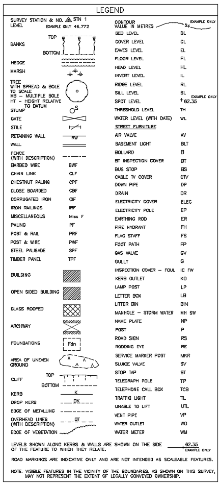
All unobstructed/visible street furniture and service covers shall be surveyed at surface level only unless otherwise stated and annotated as per the legend (see below). If it is agreed that inverts of inspection covers and manholes will be surveyed it is assumed covers are unobstructed, will yield to reasonable force with hand tools and it is safe to do so. Where covers are lifted pipe run layout will be shown as visible in the inspection chamber and will not but traced between covers.
6. Water and Coastal Features
All natural water and coastal features shall be surveyed together with all man made features including culverts, ditches or other water course. Water levels with date and direction of flow shall be indicated. Areas of cliff, erosion and marsh shall be surveyed and annotated as per the legend.
7. Levels, Banks, Slopes and Contours
In open ground a random grid of spot levels shall be observed to indicate change of gradient and to be the basis for contouring and terrain modelling. Banks and slopes shall be indicated by a dashed line and “batter” symbol or contoured. Contour interval shall be 0.5 metre unless otherwise stated.
8. Woods, Trees and Vegetation
Mature isolated trees shall be surveyed as to plan position, bole diameter and canopy drawn to scale. Woods, copses and bushes shall be surveyed as canopy outline only.
9. Industrial
All relevant surface visible features including pipelines shall be surveyed. Pylons, masts, poles and overhead lines shall be shown in plan position and annotated as to type.
10. Land Use
Land use as visible on the ground will be indicated with text.
11. Digital Presentation of the Survey
The above will be presented in 2D (2 dimensional) AutoCad DWG format unless otherwise stated. All digital survey information will have the accuracy to that specified for the original scale and all critical dimensions shall be treated as if they were scaled unless verified by North Point Surveys. 3D Autocad output is available but must but specified prior to commencement of the survey.
12. Issue of Drawings
Survey drawings will be issued via email to the party commissioning the work.
A copy of the Legend used by North Point Surveys is shown below:


